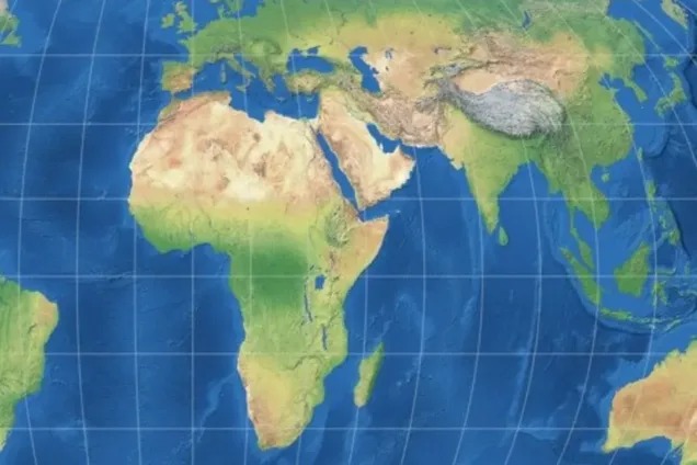

The Ghana Institute of Governance and Security (GIGS) has welcomed a United Nations General Assembly resolution backing the Equal Earth map projection, describing the move as an important step towards changing how Africa’s size and significance are perceived around the world.
GIGS said the decision could help address what it considers centuries of distortion associated with the widely used Mercator projection, which has often made Africa appear considerably smaller than it is in reality.
The UN General Assembly adopted the resolution on Friday, September 4, 2026, with 164 countries voting in favour and only one voting against it.
Six countries including Estonia, Georgia, Lithuania, Moldova, Serbia and Ukraine abstained.
The resolution was sponsored by Togo on behalf of the African Union and co-sponsored by the Bahamas, while the United States was the only country to vote against it.
In a statement signed by its Executive Director, Dr David Agbee, GIGS said the development, together with a separate UN resolution recognising the Transatlantic Slave Trade as one of the gravest crimes against humanity, represents a significant moment in efforts to address historical injustices affecting Africa.
The organisation argued that the debate over maps goes beyond geography, insisting that the way the world is visually represented can influence perceptions of power, importance and opportunity.
GIGS cited Togo’s Foreign Minister, Robert Dussey, who argued before the vote that “a fair world begins with a fair map” and that “a map is never neutral.”
GIGS said it agreed with the position, stressing that maps can shape how children understand the world, how investors view different regions and how countries perceive their place within the international system.
“Maps are not passive renderings of geography — they are instruments of power,” the organisation said.
It said the continued use of projections that visually reduce Africa could have consequences beyond cartography.
“A map that visually diminishes a continent of 1.4 billion people does not merely misinform. It conditions generations to underestimate Africa’s scale, its resources, and its significance,” GIGS said.
The organisation explained that the Mercator projection was created in 1569 mainly to assist European sailors with navigation. However, because the projection enlarges areas closer to the poles while reducing the apparent size of regions near the equator, Africa is significantly distorted in conventional representations.
GIGS pointed to the comparison between Africa and Greenland as a striking example. While Africa is approximately 14 times larger than Greenland, the two landmasses can appear much closer in size on a Mercator map.
The organisation said the continued dominance of such maps in classrooms, media organisations and digital platforms has allowed what it describes as a historical imbalance to persist into the modern era.
It also raised concerns about colonial-era borders, which it said were largely drawn by European powers with limited consideration for Africa’s ethnic, cultural and historical realities.
According to GIGS, the UN resolution should therefore be viewed as more than a change in cartographic preference.
“Correcting the map is therefore not a symbolic gesture,” it said, describing the resolution as “one deliberate step toward correcting the broader architecture of perception that has long under-represented Africa’s true scale and standing in the world.”
GIGS noted that the overwhelming vote in favour of the resolution signals growing international recognition that historical biases embedded in everyday tools can be confronted and corrected.
It further pointed to France’s decision to abandon the Mercator projection in its official maps as an indication that the issue extends beyond Africa.
The organisation, however, acknowledged that the UN resolution is not legally binding and does not prevent the continued use of Mercator for specialised purposes such as maritime and aerial navigation, where its technical characteristics remain useful.
Instead, the resolution encourages the use of equal-area projections such as Equal Earth where accurately portraying the relative size of countries and continents is important.
GIGS is now urging Ghanaian and African education authorities to incorporate Equal Earth maps into school curricula, textbooks and other educational materials.
It also wants African governments and the African Union to maintain momentum behind the “Correct the Map” campaign and broaden discussions to include the legacy of colonial-era borders.
The organisation is further calling on technology companies and media houses to reconsider the map projections used on their digital platforms so that the change endorsed at the UN level can eventually be reflected in the everyday experiences of users.
GIGS also urged the international community to build on the UN resolutions concerning the Transatlantic Slave Trade and global map representation as part of wider efforts to confront historical injustices.
The institute expressed appreciation to the UN General Assembly, Togo, Foreign Minister Robert Dussey, the African Union, the Bahamas and advocacy groups including Africa No Filter and Speak Up Africa for supporting the campaign.
“A fair world does indeed begin with a fair map,” GIGS said, urging Ghana to ensure that the development translates beyond maps into changes in “perception, policy, and practice.”